Map of Mamluk Territory
Item
Title
Map of Mamluk Territory
Description
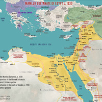
This is a map showing what the Mamluk Sultanate looked like in 1330. It also shows the other major states in the region as well as the area of the previous Ayyubid Sultanate
Creator
Simeon Netchev
Temporal Coverage
June 3, 2022
Spatial Coverage
unknown
Type
Image
Date Created
June 3 2022
Source
https://www.worldhistory.org/image/16003/mamluk-sultanate-of-egypt-c-1330/
Contributor
Melanie Brew
Rights
CC BY-NC-SA 4.0)