Manipulated Mercator Projection of the World
Item
Title
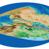
Manipulated Mercator Projection of the World
Description
This world map has been edited to better fit the general understanding of medieval Islamic representations of the globe. The North and South American continents have been removed, the map has been rotated 180 degrees, and the tip of Africa has been stretched to meet Australia.
Creator
Karen C. Pinto
Temporal Coverage
November 2016
Spatial Coverage
Unknown
Type
Manipulated Image
Source
Pinto, Karen C. “KMMS World Maps Primer” in Medieval Islamic Maps: An Exploration, 59 – 78. Chicago: University of Chicago Press, November 2016.
Contributor
Leigha DeRango
Rights
Karen C. Pinto